Have you ever wondered how your phone knows exactly where you are — even when you’re lost in a foreign city or driving through an unfamiliar neighborhood? It’s not magic, and it’s definitely not luck. Behind that little blue dot on your screen lies one of the most impressive technological achievements of the modern era: the Global Positioning System, or GPS.
GPS has become such a regular part of our lives that we often take it for granted. From finding the nearest coffee shop to tracking packages and even synchronizing time across global networks, GPS plays a crucial role in more ways than we realize. But how does this invisible guide actually work?
In this article, we’ll break down the science behind GPS in simple terms, explore how satellites communicate with devices on Earth, and uncover the fascinating technology that allows us to navigate our world with just a few taps on a screen. Whether you’re a curious learner, a tech enthusiast, or simply someone who relies on maps every day, understanding how GPS works will give you a new appreciation for the invisible network above us all.
Let’s start from the beginning — the satellites that make it all possible.
1. Satellites: The Eyes in the Sky
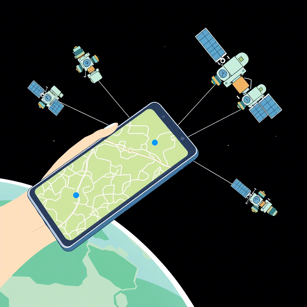
At the heart of GPS is a constellation of satellites orbiting Earth at an altitude of about 20,200 kilometers (12,550 miles). These satellites, maintained by the U.S. Space Force, are constantly circling the planet, making sure that no matter where you are, at least four of them are visible above the horizon.
Each satellite continuously broadcasts signals containing its position and the exact time the signal was sent. These signals travel at the speed of light — around 300,000 kilometers per second — and reach GPS receivers like the ones in your smartphone or car navigation system.
But here’s the key: your device doesn’t send anything back . It simply listens to these signals and uses clever math to figure out where you are. This process is known as trilateration , and it’s how GPS determines your location with surprising accuracy.
Think of it like this: if you know how far you are from three different points, you can pinpoint your exact location. That’s essentially what your GPS device does — only instead of using landmarks on a map, it uses satellites high above the Earth.
Now that you understand the basics of how satellites play their role, let’s dive deeper into how your GPS receiver processes all this information.
2. Trilateration: How Your Location Is Calculated
Imagine you’re standing somewhere unknown, and someone tells you that you’re 10 kilometers away from a lighthouse. You now know you’re somewhere on a circle with a 10-kilometer radius around that lighthouse. If they tell you you’re also 15 kilometers from another lighthouse, you must be at one of the two points where those circles intersect.
Add a third lighthouse, and you’ll narrow it down to just one point. That’s the basic idea behind trilateration — the mathematical method GPS uses to determine your location.
Your GPS receiver does something very similar but in three dimensions. Each satellite sends a signal that includes the time it was sent. Since the receiver knows the speed of light, it calculates how long the signal took to arrive and then figures out how far away the satellite is.
With data from at least four satellites , the receiver can calculate your latitude, longitude, and altitude — and even correct for timing errors in the receiver’s internal clock.
This process happens in a fraction of a second and is repeated multiple times each second to provide real-time updates as you move. The result? A smooth, accurate blue dot on your map that shows exactly where you are.
So now that you know how your location is calculated, you might be wondering: how do these satellites stay so precise, and why do they need atomic clocks?
3. Atomic Clocks and Timing Precision
One of the most fascinating aspects of GPS technology is the incredible precision required to make it work. At the core of this precision are atomic clocks — some of the most accurate timekeeping devices ever built.
Each GPS satellite carries multiple atomic clocks , typically based on either cesium or rubidium atoms. These clocks are so accurate that they lose or gain less than a microsecond over millions of years. To put that in perspective, a single millisecond error could throw off your GPS location by hundreds of kilometers!
Because GPS relies on the time it takes for signals to travel from satellites to your receiver, even tiny timing errors can have big consequences . That’s why these ultra-precise clocks are essential. They ensure that the timestamps included in each satellite’s signal are perfectly synchronized.
But there’s another challenge: Einstein’s theory of relativity . Believe it or not, GPS has to account for both special and general relativity. Because the satellites are moving at high speeds and are farther from Earth’s gravity, their clocks would naturally tick faster than clocks on the ground by about 38 microseconds per day.
If engineers didn’t adjust for this, GPS would accumulate errors of about 10 kilometers every day! So, to keep everything aligned, the clocks on satellites are intentionally set to run slightly slower to compensate for these relativistic effects.
It’s amazing to think that a system designed to help us find our way relies on physics theories developed over a century ago. Now that you’ve seen how timing plays a critical role, let’s explore how GPS performs under different conditions.
4. Accuracy and Limitations: When GPS Can Go Wrong
While GPS is incredibly reliable, it’s not perfect. There are several factors that can affect its accuracy, sometimes leading to frustrating mismatches between your actual location and the one shown on your screen.
One of the biggest challenges is signal interference . GPS signals are relatively weak by the time they reach Earth, which means they can be easily blocked or reflected by tall buildings, dense forests, or even heavy cloud cover. This phenomenon, known as multipath interference , occurs when signals bounce off surfaces before reaching your receiver, causing confusion in distance calculations.
Another factor affecting GPS accuracy is satellite geometry . Ideally, the satellites used for trilateration should be spread out in different parts of the sky. If they’re clustered too closely together, the resulting position calculation becomes less precise. GPS systems use a value called DOP (Dilution of Precision) to measure how good the satellite arrangement is at any given moment.
Weather can also play a role. Although rare, solar storms and ionospheric disturbances can disrupt GPS signals, especially near the poles or during periods of high solar activity.
And finally, while civilian GPS is usually accurate within a few meters, military-grade GPS offers even higher precision — often within centimeters. This enhanced accuracy comes from encrypted signals and advanced correction techniques that aren’t available to the public.
Despite these limitations, GPS remains one of the most powerful tools we have for navigation. And thanks to ongoing improvements, it’s getting better all the time.
Now that you understand how GPS can be affected by external factors, let’s look at how other technologies are enhancing GPS today.
5. Augmented GPS: Enhancing Navigation with New Technologies
As useful as GPS is on its own, it’s becoming even more powerful when combined with other technologies. These enhancements help improve accuracy, reliability, and functionality — especially in challenging environments.
One of the most common upgrades is Assisted GPS (A-GPS) . This system uses cellular networks to provide GPS receivers with additional information, such as satellite positions and approximate time. By doing so, A-GPS helps devices lock onto satellite signals faster, especially in areas with poor signal strength.
Another advancement is Real-Time Kinematic (RTK) GPS , widely used in agriculture, surveying, and drone navigation. RTK improves accuracy by using a fixed base station to correct GPS signals in real time. This technique can achieve centimeter-level precision, making it ideal for applications where small errors can have big consequences.
Then there’s Indoor Positioning Systems (IPS) , which aim to solve the problem of GPS not working indoors. While GPS struggles inside buildings due to signal blockage, IPS technologies use Wi-Fi, Bluetooth beacons, or even magnetic field mapping to locate users indoors. These systems are increasingly being integrated into shopping malls, airports, and hospitals to offer seamless indoor navigation.
Additionally, sensor fusion is playing a growing role in modern navigation. Smartphones and cars now combine GPS with accelerometers, gyroscopes, and compasses to estimate movement when satellite signals are temporarily lost — such as when driving through a tunnel or walking through a subway station.
These advancements show that GPS isn’t just standing still — it’s evolving alongside other cutting-edge technologies to offer smarter, more accurate navigation than ever before.
Now that we’ve explored how GPS works and how it’s being improved, let’s take a step back and look at how this groundbreaking system came to be.
6. The Origins of GPS: From Military Tool to Everyday Essential
The story of GPS begins not with smartphones or car navigation systems, but with the Cold War and the need for precise military positioning.
The first seeds of GPS were planted in the 1960s when the U.S. Department of Defense began developing satellite-based navigation systems for submarines carrying nuclear missiles. One early example was the Transit system , which allowed Navy vessels to determine their location by measuring the Doppler shift of satellite signals.
However, Transit had limitations — it provided updates only once every hour or so and wasn’t accurate enough for fast-moving aircraft or vehicles. Recognizing the need for a better system, the U.S. Air Force launched the first GPS satellite in 1978 as part of a project called NAVSTAR .
By the early 1990s, GPS became fully operational with a full constellation of satellites. Initially reserved for military use, it was opened up for civilian applications after a tragic incident in 1983, when Korean Air Lines Flight 007 strayed into Soviet airspace and was shot down. In response, President Ronald Reagan announced that GPS would be made freely available to civilians to improve global air safety.
Over the decades, GPS evolved from a specialized tool into a universal utility. Today, it powers everything from ride-sharing apps to weather forecasting, proving that what started as a military necessity has become an indispensable part of everyday life.
Now that you know how GPS got its start, let’s explore how other countries have developed their own satellite navigation systems.
7. Global Competitors: Other Satellite Navigation Systems Around the World
While GPS remains the most well-known satellite navigation system, it’s no longer the only one. Several countries and organizations have developed their own systems to reduce dependence on the U.S.-controlled GPS and provide alternative services with regional or global coverage.
One of the most prominent is GLONASS , Russia’s version of GPS. Developed during the Soviet era and fully restored in the 2000s, GLONASS operates with a constellation of 24 satellites and provides global coverage. Many modern smartphones and navigation systems use both GPS and GLONASS to improve accuracy and signal availability.
China has also entered the space race with BeiDou , a system that started as a regional service and expanded into a full global constellation by 2020. BeiDou offers unique features like short message communication, allowing users to send text messages even without mobile network coverage — a valuable capability in remote areas.
The European Union is building its own system called Galileo , which aims to offer high-precision civilian positioning independent of military control. Galileo promises better accuracy than GPS alone and includes search-and-rescue capabilities.
India has developed the NavIC system (Navigation with Indian Constellation), primarily serving the Indian subcontinent and surrounding regions. It’s used for transportation, disaster management, and even fishing boat tracking.
These systems don’t replace GPS — rather, they complement it. Many modern devices use signals from multiple constellations simultaneously, combining data from GPS, GLONASS, BeiDou, and Galileo to deliver faster fixes and more reliable performance, especially in difficult environments like cities with tall buildings.
This global expansion of satellite navigation reflects how essential these systems have become — not just for individuals, but for entire economies and infrastructures.
Now that you’ve seen how GPS fits into a broader international landscape, let’s look ahead at what the future holds for satellite navigation.
8. The Future of GPS: What’s Next for Satellite Navigation?
As technology continues to advance, so too does GPS — and the future looks incredibly promising. Researchers and engineers are already working on next-generation improvements that will make satellite navigation faster, more accurate, and more secure.
One exciting development is the rollout of GPS III , the latest generation of GPS satellites. These satellites feature more powerful signals, improved accuracy, and enhanced resistance to jamming and spoofing — a growing concern in both military and civilian applications.
Another major trend is the integration of quantum technologies into navigation systems. Scientists are exploring the use of quantum sensors and atomic clocks that could dramatically improve GPS accuracy and potentially allow for navigation in places where satellite signals can’t reach, like underwater or underground.
Artificial intelligence is also entering the mix. Machine learning algorithms are being trained to predict and correct GPS errors in real time, improving performance in urban environments and reducing reliance on perfect satellite visibility.
Meanwhile, companies are experimenting with space-based augmentation systems that use geostationary satellites to enhance GPS signals over large regions. These systems are already used in aviation and maritime navigation and are expected to become more widespread.
Even more futuristic concepts are being explored, such as lunar GPS — a proposed system that would support future missions to the Moon by providing astronauts and robotic explorers with reliable navigation tools.
All of these innovations suggest that GPS will continue to evolve far beyond what we imagined when we first tapped on a digital map. As we move toward a more connected, autonomous, and intelligent world, satellite navigation will remain a cornerstone of modern life.
Now that we’ve covered how GPS works, its history, its limitations, and its future, let’s wrap up with a summary of everything we’ve learned.
Conclusion: Navigating the Future with GPS
From the satellites orbiting high above Earth to the tiny chip in your smartphone, GPS is a marvel of engineering that touches nearly every aspect of modern life. We’ve explored how it uses trilateration, atomic clocks, and complex timing to pinpoint your location anywhere on the planet. We’ve also seen how GPS has evolved from a military tool into a global utility used by billions of people every day.
Despite its incredible accuracy, GPS isn’t immune to challenges like signal interference or environmental obstacles. However, with the help of newer technologies like Assisted GPS, RTK, and sensor fusion, its performance continues to improve.
Around the world, other countries have developed their own satellite navigation systems, creating a richer and more resilient global positioning ecosystem. And looking ahead, the future of GPS is bright — with quantum-enhanced navigation, AI-driven corrections, and even plans for lunar positioning systems on the horizon.
Understanding how GPS works not only deepens our appreciation for the technology we use daily, but also opens the door to imagining new possibilities for its use.
So the next time you open a map app, remember: you’re tapping into a vast, invisible network of satellites that’s been decades in the making — and it’s still growing.
Wat’s your favorite way to use GPS? Whether it’s navigating a road trip, tracking your fitness goals, or discovering hidden gems in your city, we’d love to hear your stories. Share your thoughts in the comments below — and don’t forget to pass this knowledge along to others who might appreciate knowing how their favorite navigation tool really works.

Marcos Vinicius is a passionate content writer and creator with a strong focus on digital communication. With experience in crafting compelling texts for various platforms, he specializes in creating engaging and strategic content that resonates with audiences. Whether through articles, social media posts, or marketing copy, Marcos combines creativity with precision to deliver impactful messages. Committed to continuous learning and innovation, he stays up-to-date with the latest trends in content creation and digital storytelling.